Address: 27500 (From 27500 To 27599) 132ND AVE SE (Southeast), KENT, WA 98042-9038, USA
What's 98042-9038? 98042-9038 is a ZIP Code 5 Plus 4 number of 27500 (From 27500 To 27599) 132ND AVE SE (Southeast), KENT, WA, USA. Below is detail information.
98042-9038 Basic Information

-
ZIP Code 5 Plus 4:
98042-9038 -
ZIP Code 5:
98042 -
Plus 4?90384-digits that are used to identify a geographic segment within the 5-digit delivery area, such as a city block or a group of apartments or an individual high-volume receiver of mail, or any other unit that could use an extra identifier to aid in efficient mail sorting and delivery. This code is the low end of the range of +4 Codes that pertain to this ZIP Code. ZIP+4 Codes associated with nondelivery areas are composed of valid ZIP sector numbers and "ND" for the ZIP segment number, for example 12345-12ND. Non-deliverable areas are areas to which the USPS does not deliver mail, such as vacant lots and land that borders railroad tracks. Mailers should not match an address identified as a nondelivery area. If you absolutely must have numeric characters in the Plus4Code column, you may treat "ND" values as "00" (zero zero).:
-
Country:
U.S. - United States -
State:
WA - Washington -
County:
CountyFIPS: 53033 - King County -
City:
KENT -
Street?132ND AVEThe official name of a street as assigned by a local governing authority. The Street Name column contains only the street name and does not include directionals (EAST, WEST, etc.) or suffixes (ST, DR, BLVD, etc.). This element may also contain literals, such as PO BOX, GENERAL DELIVERY, USS, PSC, or UNIT. Numeric street names that have numeric components that are four characters (or less) in length at are justified such that the low-order digit of the number is positioned in the fourth position of the street name column. This shift is made so that the numeric street names appear in numeric sequence.:
-
Street Suffix?AVE (Avenue)The street suffix: For Example: ST = Street RD = Road DR = Drive LN = Lane:
-
Street Postdirectional?SE (Southeast)A geographic direction that precedes the street name. For Example: 472 MAIN ST N Street Pre-Direction Abbreviation = N Spaces = No pre-direction N = North NE = Northeast E = East SE = Southeast S = South SW = Southwest W = West NW = Northwest:
-
Record Type?S: StreetAn alphabetic value that identifies the type of data in the record. Record type codes include the following: G = General delivery H = Highrise F = Firm S = Street P = PO box R = Rural route/highway contract:
Address

- Address Primary Low Number?
A house, rural route, highway contract box, or post office box number; the numeric or alphanumeric component of an address preceding the street name; the low-end address in a range of addresses. Often referred to as house number.: 27500
- Address Primary High Number?
A house, rural route, contract box, or Post Office box number. The numeric or alphanumeric component of an address preceding the street name. The high-end address in a range of addresses. Often referred to as house number.: 27599
- Address Primary Odd / Even Code?
Code that identifies the side or sides of a street for which a given address range is applicable. For street, highrise, firm and multi-carrier records, B = Both sides of a street, E = Even side of a street (even-numbered addresses in the range); O = Odd side of a street (odd-numbered addresses in the range). For general delivery, post office box, and rural route/highway contract records, this code will always be "B" (both).: Both of Odd and Even
- Primary Range: 27500, 27501, 27502, 27503, 27504, 27505, 27506, 27507, 27508, 27509, 27510, 27511, 27512, 27513, 27514, 27515, 27516, 27517, 27518, 27519, 27520, 27521, 27522, 27523, 27524, 27525, 27526, 27527, 27528, 27529, 27530, 27531, 27532, 27533, 27534, 27535, 27536, 27537, 27538, 27539, 27540, 27541, 27542, 27543, 27544, 27545, 27546, 27547, 27548, 27549, 27550, 27551, 27552, 27553, 27554, 27555, 27556, 27557, 27558, 27559, 27560, 27561, 27562, 27563, 27564, 27565, 27566, 27567, 27568, 27569, 27570, 27571, 27572, 27573, 27574, 27575, 27576, 27577, 27578, 27579, 27580, 27581, 27582, 27583, 27584, 27585, 27586, 27587, 27588, 27589, 27590, 27591, 27592, 27593, 27594, 27595, 27596, 27597, 27598, 27599.
Please click the "More Address Examples" to view the whole list.
27500 132ND AVE SE (Southeast), KENT, WA 98042-9038
27501 132ND AVE SE (Southeast), KENT, WA 98042-9038
27502 132ND AVE SE (Southeast), KENT, WA 98042-9038
27503 132ND AVE SE (Southeast), KENT, WA 98042-9038
27504 132ND AVE SE (Southeast), KENT, WA 98042-9038
27505 132ND AVE SE (Southeast), KENT, WA 98042-9038
27506 132ND AVE SE (Southeast), KENT, WA 98042-9038
27507 132ND AVE SE (Southeast), KENT, WA 98042-9038
27508 132ND AVE SE (Southeast), KENT, WA 98042-9038
27509 132ND AVE SE (Southeast), KENT, WA 98042-9038
27510 132ND AVE SE (Southeast), KENT, WA 98042-9038
27511 132ND AVE SE (Southeast), KENT, WA 98042-9038
27512 132ND AVE SE (Southeast), KENT, WA 98042-9038
27513 132ND AVE SE (Southeast), KENT, WA 98042-9038
27514 132ND AVE SE (Southeast), KENT, WA 98042-9038
27515 132ND AVE SE (Southeast), KENT, WA 98042-9038
27516 132ND AVE SE (Southeast), KENT, WA 98042-9038
27517 132ND AVE SE (Southeast), KENT, WA 98042-9038
27518 132ND AVE SE (Southeast), KENT, WA 98042-9038
27519 132ND AVE SE (Southeast), KENT, WA 98042-9038
27520 132ND AVE SE (Southeast), KENT, WA 98042-9038
27521 132ND AVE SE (Southeast), KENT, WA 98042-9038
27522 132ND AVE SE (Southeast), KENT, WA 98042-9038
27523 132ND AVE SE (Southeast), KENT, WA 98042-9038
27524 132ND AVE SE (Southeast), KENT, WA 98042-9038
27525 132ND AVE SE (Southeast), KENT, WA 98042-9038
27526 132ND AVE SE (Southeast), KENT, WA 98042-9038
27527 132ND AVE SE (Southeast), KENT, WA 98042-9038
27528 132ND AVE SE (Southeast), KENT, WA 98042-9038
27529 132ND AVE SE (Southeast), KENT, WA 98042-9038
27530 132ND AVE SE (Southeast), KENT, WA 98042-9038
27531 132ND AVE SE (Southeast), KENT, WA 98042-9038
27532 132ND AVE SE (Southeast), KENT, WA 98042-9038
27533 132ND AVE SE (Southeast), KENT, WA 98042-9038
27534 132ND AVE SE (Southeast), KENT, WA 98042-9038
27535 132ND AVE SE (Southeast), KENT, WA 98042-9038
27536 132ND AVE SE (Southeast), KENT, WA 98042-9038
27537 132ND AVE SE (Southeast), KENT, WA 98042-9038
27538 132ND AVE SE (Southeast), KENT, WA 98042-9038
27539 132ND AVE SE (Southeast), KENT, WA 98042-9038
27540 132ND AVE SE (Southeast), KENT, WA 98042-9038
27541 132ND AVE SE (Southeast), KENT, WA 98042-9038
27542 132ND AVE SE (Southeast), KENT, WA 98042-9038
27543 132ND AVE SE (Southeast), KENT, WA 98042-9038
27544 132ND AVE SE (Southeast), KENT, WA 98042-9038
27545 132ND AVE SE (Southeast), KENT, WA 98042-9038
27546 132ND AVE SE (Southeast), KENT, WA 98042-9038
27547 132ND AVE SE (Southeast), KENT, WA 98042-9038
27548 132ND AVE SE (Southeast), KENT, WA 98042-9038
27549 132ND AVE SE (Southeast), KENT, WA 98042-9038
27550 132ND AVE SE (Southeast), KENT, WA 98042-9038
27551 132ND AVE SE (Southeast), KENT, WA 98042-9038
27552 132ND AVE SE (Southeast), KENT, WA 98042-9038
27553 132ND AVE SE (Southeast), KENT, WA 98042-9038
27554 132ND AVE SE (Southeast), KENT, WA 98042-9038
27555 132ND AVE SE (Southeast), KENT, WA 98042-9038
27556 132ND AVE SE (Southeast), KENT, WA 98042-9038
27557 132ND AVE SE (Southeast), KENT, WA 98042-9038
27558 132ND AVE SE (Southeast), KENT, WA 98042-9038
27559 132ND AVE SE (Southeast), KENT, WA 98042-9038
27560 132ND AVE SE (Southeast), KENT, WA 98042-9038
27561 132ND AVE SE (Southeast), KENT, WA 98042-9038
27562 132ND AVE SE (Southeast), KENT, WA 98042-9038
27563 132ND AVE SE (Southeast), KENT, WA 98042-9038
27564 132ND AVE SE (Southeast), KENT, WA 98042-9038
27565 132ND AVE SE (Southeast), KENT, WA 98042-9038
27566 132ND AVE SE (Southeast), KENT, WA 98042-9038
27567 132ND AVE SE (Southeast), KENT, WA 98042-9038
27568 132ND AVE SE (Southeast), KENT, WA 98042-9038
27569 132ND AVE SE (Southeast), KENT, WA 98042-9038
27570 132ND AVE SE (Southeast), KENT, WA 98042-9038
27571 132ND AVE SE (Southeast), KENT, WA 98042-9038
27572 132ND AVE SE (Southeast), KENT, WA 98042-9038
27573 132ND AVE SE (Southeast), KENT, WA 98042-9038
27574 132ND AVE SE (Southeast), KENT, WA 98042-9038
27575 132ND AVE SE (Southeast), KENT, WA 98042-9038
27576 132ND AVE SE (Southeast), KENT, WA 98042-9038
27577 132ND AVE SE (Southeast), KENT, WA 98042-9038
27578 132ND AVE SE (Southeast), KENT, WA 98042-9038
27579 132ND AVE SE (Southeast), KENT, WA 98042-9038
27580 132ND AVE SE (Southeast), KENT, WA 98042-9038
27581 132ND AVE SE (Southeast), KENT, WA 98042-9038
27582 132ND AVE SE (Southeast), KENT, WA 98042-9038
27583 132ND AVE SE (Southeast), KENT, WA 98042-9038
27584 132ND AVE SE (Southeast), KENT, WA 98042-9038
27585 132ND AVE SE (Southeast), KENT, WA 98042-9038
27586 132ND AVE SE (Southeast), KENT, WA 98042-9038
27587 132ND AVE SE (Southeast), KENT, WA 98042-9038
27588 132ND AVE SE (Southeast), KENT, WA 98042-9038
27589 132ND AVE SE (Southeast), KENT, WA 98042-9038
27590 132ND AVE SE (Southeast), KENT, WA 98042-9038
27591 132ND AVE SE (Southeast), KENT, WA 98042-9038
27592 132ND AVE SE (Southeast), KENT, WA 98042-9038
27593 132ND AVE SE (Southeast), KENT, WA 98042-9038
27594 132ND AVE SE (Southeast), KENT, WA 98042-9038
27595 132ND AVE SE (Southeast), KENT, WA 98042-9038
27596 132ND AVE SE (Southeast), KENT, WA 98042-9038
27597 132ND AVE SE (Southeast), KENT, WA 98042-9038
27598 132ND AVE SE (Southeast), KENT, WA 98042-9038
27599 132ND AVE SE (Southeast), KENT, WA 98042-9038
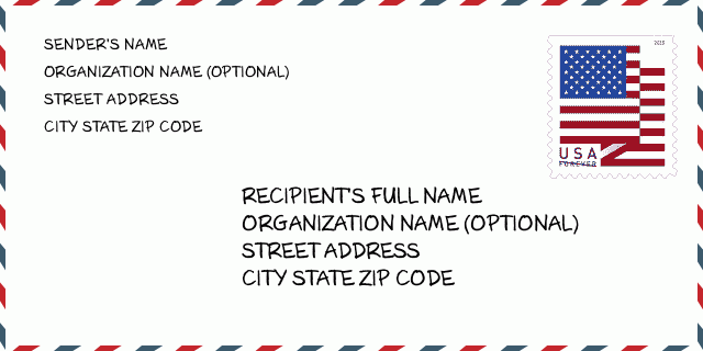
Address Example
KENT WA 98042-9038
UNITED STATES OF AMERICA
98042-9038 Envelope Example

-
This is an example of U.S envelope. Fill in the sender's information at the top left and the recipient information at the bottom right. The necessary information is sender/recipient's full name, street address, city, state and zip code. The recipient address information has been given for your reference. Generally, If you are not sure of the full 9-digit zip code, you can only fill in the 5-digit zip code to avoid loss of package.
98042-9038 Basic Meaning
-
What does each digit of ZIP Code 98042-9038 stands for? ZIP+4 Code consists of two parts, the first five digits can be located to the post office, and the last four digits can identify a geographic segment within the five-digit delivery area. The 6-7 digits designate sector or several blocks, and the 8-9 digits designate segment or one side of a street.
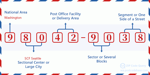

- ·Carrier Route ID?
A 4-digit code assigned to a mail delivery or collection route within a 5-digit ZIP Code. The first character of this identification is alphabetical, and the last three are numeric: Bnnn = PO box Hnnn = Highway contract Rnnn = Rural route Cnnn = City delivery Gnnn = General delivery: C092 (City delivery)
- ·ZIP Add-On Low Sector?
The ZIP Add-On Low Sector and the ZIP Add-On Low Segment together form the ZIP Add-On Low Number. The ZIP Add-On Low Number is the last four positions of a ZIP+4 code; the low-end ZIP add-on in a range of codes; the add-on of the first ZIP+4 code in a consecutive series of ZIP+4 codes assigned to the delivery address. For example, most delivery addresses are assigned a single ZIP+4 code. However, large companies may be given a range of ZIP+4 codes that can be used to route mail to specific departments. A range of ZIP+4 codes can also be assigned to a corresponding range of post office boxes, and each box is mapped, one-to-one, with a ZIP+4 code in the range. A single post office box can also be assigned a range of ZIP+4 codes.: 90
- ·ZIP Add-On Low Segment?
The ZIP Add-On Low Sector and the ZIP Add-On Low Segment together form the ZIP Add-On Low Number. The ZIP Add-On Low Number is the last four positions of a ZIP+4 code; the low-end ZIP add-on in a range of codes; the add-on of the first ZIP+4 code in a consecutive series of ZIP+4 codes assigned to the delivery address. For example, most delivery addresses are assigned a single ZIP+4 code. However, large companies may be given a range of ZIP+4 codes that can be used to route mail to specific departments. A range of ZIP+4 codes can also be assigned to a corresponding range of post office boxes, and each box is mapped, one-to-one, with a ZIP+4 code in the range. A single post office box can also be assigned a range of ZIP+4 codes.: 38
- ·ZIP Add-On High Sector?
The ZIP Add-On High Sector and the ZIP Add-On High Segment together form the ZIP Add-On High Number, which is the high-end ZIP add-on in a range of codes; the add-on of the last ZIP+4 code in a consecutive series of ZIP+4 codes assigned to the delivery address. Most delivery addresses are assigned a single ZIP+4 code; however, large companies may be given a range of ZIP+4 codes that can be used to route mail to specific departments. A range of ZIP+4 codes can also be assigned to a corresponding range of post office boxes, and each box is mapped, one-to-one, with a ZIP+4 code in the range. A single post office box can also be assigned a range of ZIP+4 codes. (See also ZIP Add-On Code.): 90
- ·ZIP Add-On High Segment?
The ZIP Add-On High Sector and the ZIP Add-On High Segment together form the ZIP Add-On High Number, which is the high-end ZIP add-on in a range of codes; the add-on of the last ZIP+4 code in a consecutive series of ZIP+4 codes assigned to the delivery address. Most delivery addresses are assigned a single ZIP+4 code; however, large companies may be given a range of ZIP+4 codes that can be used to route mail to specific departments. A range of ZIP+4 codes can also be assigned to a corresponding range of post office boxes, and each box is mapped, one-to-one, with a ZIP+4 code in the range. A single post office box can also be assigned a range of ZIP+4 codes. (See also ZIP Add-On Code.): 38
- ·ZIP Code Add On: 9038
- ·Range?
The range of +4 codes. Summing the +4 Code and the +4 Range will give you the high end of the range of +4 Codes that pertain to this ZIP Code.: 0
- ·Base Alternate Code?
Code that specifies whether a record is a base (preferred) or alternate record. Base records (represented as "B") can represent a range of addresses or an individual address, such as a firm record, while alternate records (represented as "A") are individual delivery points. Government deliveries will only be listed on alternate records with the appropriate government building indicator (federal, state, or city) set.: Base
- ·Finance Number?
A code assigned to Postal Service facilities (primarily post offices) to collect cost and statistical data and compile revenue and expense data. The state number comprises the first two positions of the finance number.: 544060
- ·Congressional District Number?
A standard value identifying a geographic area within the United States served by a member of the US House of Representatives or Senate. If Army/Air Force (APO) or fleet post office (FPO), this column will be blank. If there is only one member of Congress within a state, the code will be "AL" (at large).: 08
- ·Preferred Last Line City State Key?
An index to the City State file that provides the preferred last-line name for this address range.: Z16970
Online Map

This is online map of the address 27500 132ND AVE, KENT. You may use button to move and zoom in / out. The map information is for reference only.
Address: 27500 (From 27500 To 27599) 132ND AVE SE (Southeast), KENT, WA 98042-9038, USA
Comment


Add new comment